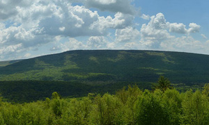
By Dr. Benjamin Carter, Muhlenberg College
I imagine that most people reading this enjoy walking in the woods and otherwise experiencing Pennsylvania’s parks, forests, and game lands. You may also know there’s an abundance of history in state lands, much of it centered on the iron industry. Indeed, I’m often surprised at how many know that charcoal production for iron furnaces was an important industry that occupied vast portions of Pennsylvania – and that this industry is still visible.
Yet, I also talk to folks who love the outdoors but do not know the history of charcoal. I have yet to find many who understand the connection between state lands, iron, charcoal, and Black history. It’s there, but you have to know where to look and what to look for.
Before I get into details, I must be clear that some of what I present will feel a bit speculative. I am still working on aspects of this research, but the evidence is rich enough to share at this point. I’m an archaeologist. “Cool. What did you dig?” you say. Umm… nothing. Yet bear with me. We’re moving in that direction. Recent experience demonstrates that researching Black communities is significantly more difficult than working on White (which I have done – a lot).
“Why is that?” First, much of the documentation we rely upon to do this work is from state, federal, and local governments (census, taxes, deeds, etc.). In the 19th century, all levels of government treated Black individuals and communities poorly. Anti-Black racism was profound, even in the “Free” state of Pennsylvania. Even most white abolitionists (except for the “radicals” like iron master Thaddeus Stevens) did not believe in equal rights for Black Americans. And within Pennsylvania governments, there were many supporters of slavery, often leading Black Pennsylvanians to protect themselves and their communities by providing misinformation. For example, across two decades of census information, an individual might have a different name (e.g., Aquila to William) or claim the same age after a decade has passed.
In 1860 (just before the Civil War), very, very few Black Pennsylvanians claimed to have been born in “slave” states – that would have potentially identified them as “fugitives.” But after the war, many of those same people reported that they were born in Maryland, Virginia, and beyond.
Images of census records for Isaac Cole from 1850 and 1870.
Secondly, throughout this time there is a massive movement of Black Americans north from the south via the Underground Railroad. While Black communities did their best to support these people, housing was in VERY short supply. So, many moved on (again and again, etc.), but sometimes returned. This sort of movement – especially of people whose “documentation” might endanger their freedom or their life – makes it much more difficult to track individuals and families.
This means that, in order to understand Black communities, we often need resources beyond the standard historical documents. One of these resources is the landscape – enter archaeology and state lands. With both new technology and good-ole walking around in the woods looking for “cultural features,” unique landscapes can be identified and studied.
If this seems on the speculative side, remember historic documents are confusing and contradictory. Yet with new techniques from archaeology, we’re getting there.
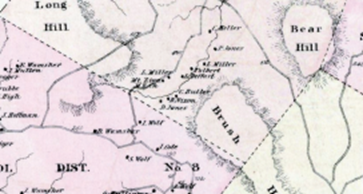
Map of Six Penny Creek from 1876. From the Illustrated Historical Atlas of Berks County by F.A. Davis
Six Penny Creek, a small rural Black settlement in southern Berks County, was established in 1842. At its peak, between 1860-1870, approximately 40-50 people lived in the community of nine houses on 40 acres of land owned by community members. They built a church, the Mt. Frisby African Methodist Episcopal (AME) Church, and a cemetery. As archaeologist Cheryl LaRoche demonstrated, AME churches were central to the Underground Railroad and local historians have long recognized Six Penny Creek as a “station.” This community was surrounded by “charcoal lands,” which provided the fuel for two iron furnaces – Hampton and Hopewell Furnaces. Today this land is part of French Creek State Park where you can “see” this community.
Ok, but why does that matter? Charcoal lands were excellent routes and places to hide for Freedom Seekers.
Really? Why? Ok, to understand this, we need to talk a bit about charcoal.
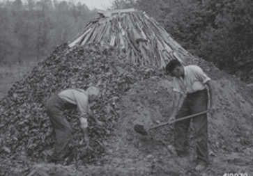
Colliers building a meiler From the National Archives 419979
To make charcoal, colliers (charcoal burners) would tightly stack wood in domed piles around 30 – 50 feet in diameter and more than 10 feet tall. This was called a “meiler.” The stack of wood was then covered with a layer of leaves and then soil before being ignited. Because it was encased, the wood did not burn but was “distilled” into gases (which leaked out of the mound) and charcoal. The charcoal was transported (usually) to furnaces, where it was used as fuel to smelt iron. Because this process could take up to eight days, colliers would have more than one meiler (up to eight) going at any one time. To tend the meiler, the colliers lived in the forest for up to eight months.
Each meiler consumed somewhere around one acre of woodland. Clemson University Forester Tom Straka has shown an iron furnace required roughly 600 acres of forest per year. Cut forest would regenerate in around 20-30 years when it could be harvested again.
At any time, vast tracts of forest would have been in the process of regrowing, in a very patchy manner. Portions of the forest would have been filled with brambles and thickets – impassable to any except those who knew the area well. These forests would have been ideal for Black Americans attempting to avoid those who would return them to slavery.
Wayne Homan, in an article entitled “The Underground Railroad” in the Historical Review of Berks County (1958) states, “An active raccoon hunter and part-time supervisor of charcoal burners, [Henry] Segner’s knowledge of the forested hills [close to Six Penny Creek] … was second to none. It was reputed that, if necessary, he could send a fleeing party of slaves, guided by a charcoal burner, in one direction, then lure a group of slave hunters to follow him all night until they were so thoroughly lost in the mountains they could not find their way out for days.”
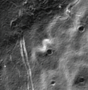
Dark circles are remnants of charcoal hearths as seen through LiDAR.
One of the coolest aspects of the charcoal industry is that it is still widely visible in state lands. I first thought that Pennsylvania had built wonderful tenting spots all across the land (you can especially see these along the Appalachian Trail). However, before a meiler is built, the land is leveled and flattened. When the meiler is abandoned this flat area, called a relict charcoal hearth, remains, leaving a wonderful tent site. You can see these on the landscape, but they tend to be hundreds of feet apart, and locating them can take a long time (I’ve visited well over 300).
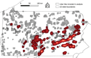
Map showing charcoal fields across Pennsylvania based solely upon an analysis of PA State Game Lands.
Using a type of remote sensing called LiDAR, an incredibly high-resolution “picture” of the ground surface can be produced. Using LiDAR and machine learning, my colleagues, Jeff Blackadar and Weston Conner, and I have identified approximately 26,000 relict charcoal heaths in and around state game lands.
We know that many of the small, rural Black communities in Pennsylvania were near these charcoal lands – evidence of the importance of the connection. We’re trying to map this, but many of these communities have been abandoned.
While these charcoal landscapes were likely important, the small huts that colliers lived in may have been more important. Because colliers stayed in the woods for extended periods of time they needed a place to stay. So they built small huts. These huts, called “collier’s huts,” are conical in shape. Imagine a cone of long straight poles with little to no gaps between them. Cut out a small door on one side. Cover the rest with leaves, then dirt. Voila! A collier’s hut.
The hut is surrounded by a circular trench, likely for drainage as well as the source of the soil covering the hut. Inside, the center may have been six feet high; the only furniture was two small sleeping benches – one for the collier and one for the assistant. The interior diameter was around 6-8 feet. These were mostly for sleeping and weather protection, as most activities took place at the charcoal hearths or outside the hut. Huts were abandoned each year as the colliers moved to the next hearth.
Before the Civil War, much of the charcoal lands would have been littered with small, abandoned, but easily repaired structures. Homan states, referring to a valley a few miles from Six Penny Creek (near SGL 52), “The slave hunters ranged that valley too, and when they pressed too hard, runaways were taken ‘into the woods’ to charcoal burners huts.” Referring to a different, but nearby location, he adds, “To avoid pursuers, some fugitives hid out in the woods in the huts of charcoal burners working for Joanna Furnace.” Joanna Furnace is a few miles west of Six Penny Creek. Referring specifically to Six Penny Creek, Homan wrote, “They [the residents of Six Penny Creek] joined the Underground Railroad and earned their living as charcoal burners.” The 1880 census lists five of the fifteen people with an occupation at Six Penny Creek as “colliers.” Six Penny Creek is just one of these small, rural Black communities adjacent to charcoal lands.
Most collier huts were abandoned annually. Normally. I have encountered two important situations in which collier huts were not abandoned. Both were in Black communities, indicating a deeper connection to the structures. The first were the homes of the “outlaws” of the Welsh Mountains. When searching for these outlaws, a reporter (Lancaster Examiner; May 6, 1885) described the house of Cal Green, a Black woman and the purported “Queen of the Welsh Mountains.” He wrote, “when they want a new house, they take a few fence rails, stand them on end in a circle, and plaster them with mud, leaving a small hole for the door.” Sounds like a collier hut, right?
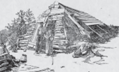
John Henson’s cabin. Philadelphia Times Aug 12, 1894
In a separate article, in the Philadelphia Times (Aug. 12, 1894), a reporter visited. John Henson, a Black man who had lived in the Welsh mountains for 40 years. Although the description doesn’t mention the shape of his home which is partially “covered with sod,” an accompanying photograph shows that the front portion is conical like a collier’s hut. This colliers hut, however, appears to have a modified front and an
extension built off the back.
Far away, along the northern edge of Lebanon county lived another Black collier by the name of Joseph Johns. Johns, reportedly 112 years old when he died in 1906, escaped enslavement in Virginia in the 1850s and reportedly lived in a collier hut for his 50+ years in Lebanon county. His home has been reconstructed by the Boy Scouts.
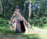
Joseph John’s reconstructed collier’s hut.
You might see one of these huts – or the remains of one at least – on your next visit to a park or forest. Evidence of collier huts remains visible on the landscape. They often look like an 8′ to 12′ diameter doughnut that has sunken into the earth, surrounded by a trench. Just above Six Penny Creek, on the land of French Creek State Park, sits the remains of one of the largest collier huts that I have seen, suggesting that it may have been used more than other huts.
These examples of Black Pennsylvanians using collier huts for longer time periods than normal demonstrate the importance of these structures as places of refuge and hint at their importance in both hiding people and ensuring that, when necessary, people could move on and build a new hut relatively easily.
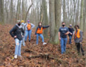
Muhlenberg College students standing on the remains of a collier’s hut.
Many people who use the public lands owned by Pennsylvania consider them “wild.” Perhaps, but they are also reservoirs of history. Lying within those lands rests an important – and rarely told – story of Black settlements who used the charcoal landscape to aid those fleeing slavery and build community. Sometimes, we just need to look, but additional ways of “looking” – such as LiDAR – can help us.

