Geologist Day is the first Sunday of April!
Geologists see the world differently. For example, where others see scenic ridge-top overlooks, a geologist might see the edge of an ancient shoreline being exposed by millions of years of uplift and erosion. Likewise, an abrupt change in the rock within a road cut may be pleasing to a driver for aesthetic reasons, however, a geologist sees a marker signaling a catastrophic extinction event. Pennsylvania’s parks and forests provide a unique opportunity for geologists, and non-geologists alike, to experience natural history in a similar manner.
Parks and Forests as Research Facilities
Parks and forests offer a unique setting where preserved public land can be treated like a natural “laboratory.” In the northeastern United States, vegetative cover and development are major obstacles that make understanding the geologic history of an area difficult. As a result, geologists at the Pennsylvania Geological Survey spend a lot of time in the field looking at rocks, sediments, and soil exposures. They take detailed notes describing the texture, composition, and in the case of bedrock, a description of the orientation of the layers of material (called “beds” for sedimentary rocks). Knowing if beds are horizontal, vertical, or somewhere in between, allows geologists to accurately map different rock formations. Individually, each one of these properties provides a glimpse into the ancient past and tells the story of how that rock came to be.
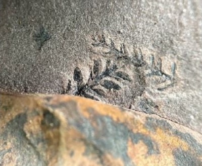
Geologists use various types of imagery to identify potential exposures of bedrock. This allows them to maximize their time collecting data “in the field” by visiting locations with the highest probability of good bedrock exposure that is also easily accessible – in essence, chasing the “low hanging fruit” first. Often, locations in parks and forests satisfy both the “best rock exposure” and “ease of access” criteria. One example of the successful application of this strategy occurred during recent geologic mapping in Bucks County. Access to outcrops in Tyler State Park provided particularly detailed insight into the geologic history of Bucks County. At one outcrop, geologists discovered plant fossils – a finding that is particularly rare within the bedrock in this area. This offered a unique opportunity to determine an age for the rocks in southern Bucks County.

Exposure of the Stockton Formation within Tyler State Park (left) where plant fossils were observed (right). | Fossil photo courtesy of Aaron Bierly, Pennsylvania Geological Survey.
Many assume that the only way to determine the age of a rock is by measuring the amount of radioactive material present in a sample. Although this is a common dating method, there are other ways to determine the age of rock material. By understanding the evolution of plants and animals through time, paleontologists can determine the age of rocks using the fossils contained within them. Fossils do not have to be full skeletons or even bits and pieces of bone material – there are other fossils that are more prevalent in rocks that can be used to determine their age, such as plant fossils. On a microscopic scale, geologists can use some unexpected materials to help them date rocks, including fossilized pollen.
If you suffer from seasonal allergies, you are all too aware that pollen is pervasive in the environment. This is true today and has been for as long as pollen-producing plants have existed. Paleontologists studying plant fossils have established the evolutionary lineage of plants and their pollen. By understanding this sequence, scientists can determine the age of a rock unit based on the different forms of pollen that are found in a sample. As for the example from Tyler State Park, the fossilized pollen found in this sample indicated that the rocks in this region are several million years younger than they were originally thought to be.
Parks and Forests as Classrooms
In addition to parks and forests being a valuable resource for conducting geological research, they serve as natural “props” that enable geoscientists to educate others about aspects of Earth’s history. The geosciences are unique in that the clues that provide insight into the Earth’s history (including rock types, colors, and patterns within the rocks) are all around us – however, the key is knowing exactly where to look and how to interpret what the rocks are telling us. Parks and forests provide a level of accessibility to geological features that foster opportunities for geologists to share their knowledge with others who are interested in learning about the Earth.
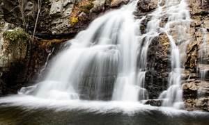
Staff from the Pennsylvania Geological Survey and Bureau of State Parks partner regularly to create educational programs based in our State Parks. For example, the Turkey Path Trail in Leonard Harrison State Park is regularly used to educate a general audience about the geology of waterfalls and geological history. Initially, these topics may not appear to be connected, but they really are. Waterfalls form where streams flow over rock layers that have different levels of resistance to erosion. Sandstones form ledges, mudstones form recesses and pools, and so on. To produce alternating layers of different sedimentary rocks, the environments in which the sediment was originally deposited must change through time.

The Turkey Path Trail in Leonard Harrison State Park is an excellent example of a natural classroom where non-geologists can learn about waterfalls and geologic history. | Source: Chris Oest, Pennsylvania Geological Survey
What can be observed when hiking from the base of the Pine Creek Gorge to the top along the Turkey Path Trail is a transition from a marine setting, inferred from rocks bearing the fossils of organisms that could only survive in ancient oceans, to a terrestrial setting, which is inferred from the abundance of red rocks that represent prolonged exposure of sediments to an oxygenated atmosphere. So, in effect, walking up the Turkey Path Trail is much like walking from the beach inland and along the bank of a river – and this geologic history is why the waterfalls are present along the trail.
Learn More and Explore
To learn more about the geology of Pennsylvania’s parks and forests, visit PaGEODE – an interactive web map and portal to Pennsylvania Geological Survey Publications, including the Trail of Geology (single page guides to geologic features throughout the Commonwealth) and geologic guides to selected State Parks.
Want to experience the “natural classroom” at Leonard Harrison State Park? Join staff from the Pennsylvania Geological Survey and Leonard Harrison State Park for a guided geology tour of the lower Turkey Path on Saturday, April 13th, 2024. Register here!
Written by Chris Oest, Senior Geoscientist at the Pennsylvania Geological Survey